Ordering & FAQs
Ordering & FAQ's
Buy Online or Purchase in Shop
1. Ordering:
You can order online using the basket system, by telephone at 053 9377835, through the post or by email. See Home Page & Contact Us for details of address etc. Your credit or debit card details will be processed by PayPal on our behalf and transferred securely.
2. Payment:
You can pay online using the basket system with your credit/debit card. All major cards can be processed inc VISA and MasterCard etc. Alternatively you can contact us by telephone with your order and credit/debit card details for payment. Other methods of payment include Postal Orders or Cheque via the post (Please note that cheques will be allowed to clear before goods are despatched which usually takes 7 days). Cheques/Postal Orders should be made out to EastWest Mapping and mailed to EastWest, Clonegal, Enniscorthy, Co.Wexford along with details of your order.
3. Delivery Information:
Postage & packing cost to Ireland & Northern Ireland is as follows: €3.00 for orders up to €16 in value, €4.00 for orders €16 to €30, €6.00 for orders €30 to €50, postage free for orders over €50. If ordering from Northern Ireland, specify country as Ireland and Carlow for county. Otherwise fill in full address.
Postage & packing on all other orders outside Ireland is as follows: €6.00 for orders up to €15 in value, €12.00 for orders €15 to €30, €18.00 for orders €30 to €50, €23.00 for orders €50 to €150, postage free for orders over €150. If your country is not listed then please contact us for a shipping quote prior to ordering. Orders are generally despatched in the next following post using An Post. Standard delivery time for Ireland is 1-2 working days. For addresses outside Ireland, allow 3-7 working days. If you are ordering a larger number of maps or a flat map packed in a postal tube (i.e. where package will not fit in your postal box), please ensure that delivery can be made by the postal service
4. Returns Policy:
If we have made a packing error and supplied you with the wrong map or publication, we apologise and please contact us to arrange for replacement. If you are not totally satisfied with your purchase or you have simply changed your mind about your purchase then in line with the Distance Selling Regulations, you must advise and return the item(s) at your own expense within 14 days. You will be responsible for the safe return of the goods. The goods must not be opened nor used and must be ‘as new’ when returned to us. Once goods are received at EastWest Mapping, we will either issue a refund or replace the item with another as required. In the latter case, you may have to pay the balance if the replacement map is more expensive and you will need to include a stamped addressed envelope and /or payment. Where the item purchased is a set of maps at a special price, you must return the full set.
5. Privacy Policy / Personal Data:
EastWest Mapping will not store your credit or debit card details. We will normally retain your postal address to facilitate future orders, your address will be kept in accordance with local law and will not be passed to any third party. We do not store your email address, however you may choose to join our mailing list by requesting this. This will enable you to receive 3-6 updates a year by email with news of map updates, new products. We communicate on a weekly basis to our customers via our Facebook page – EastWest Mapping. You need to have a Facebook account and Like our page in order to receive news snippets on local history & placenames, map updates, news etc. EastWest Mapping will handle your information with care and respect your privacy. This Privacy Policy applies to EastWest Maps mobile applications and other interactions with EastWest Mapping including support queries. If you do not agree with the terms of this Policy, do not use the EastWest Maps app. EastWest Mapping collects some personal information as you use our mobile applications in order for the applications to function. When you register with EastWest Mapping we collect your email address, and/or a Facebook or Google numeric account identifier. We collect this to uniquely identify you, enabling you to log in and out of your account. The Android version of EastWest Maps uses Mapbox for functionality. This includes an option set by Mapbox which will track your location, they use this to upgrade map detail on OpenStreetMap. You can enable or disable this tracking. Click Mapbox Telemetry and select Don’t Participate or Participate as you wish. Purchases of maps within the application are handled by your device app store, and EastWest Mapping collects no personal details from those app stores. We do not directly handle payment card details. Payments are handled by the device app store. Your device asks for your consent before the EastWest Maps mobile application first uses location, and you can withdraw that consent at any time via the device. You can ask us to delete your account and any personal data by contacting EastWest Mapping via www.eastwestmapping.ie If you have a complaint, please contact EastWest Mapping via www.eastwestmapping.ie
Q: What map scales are used for EastWest Mapping publications?
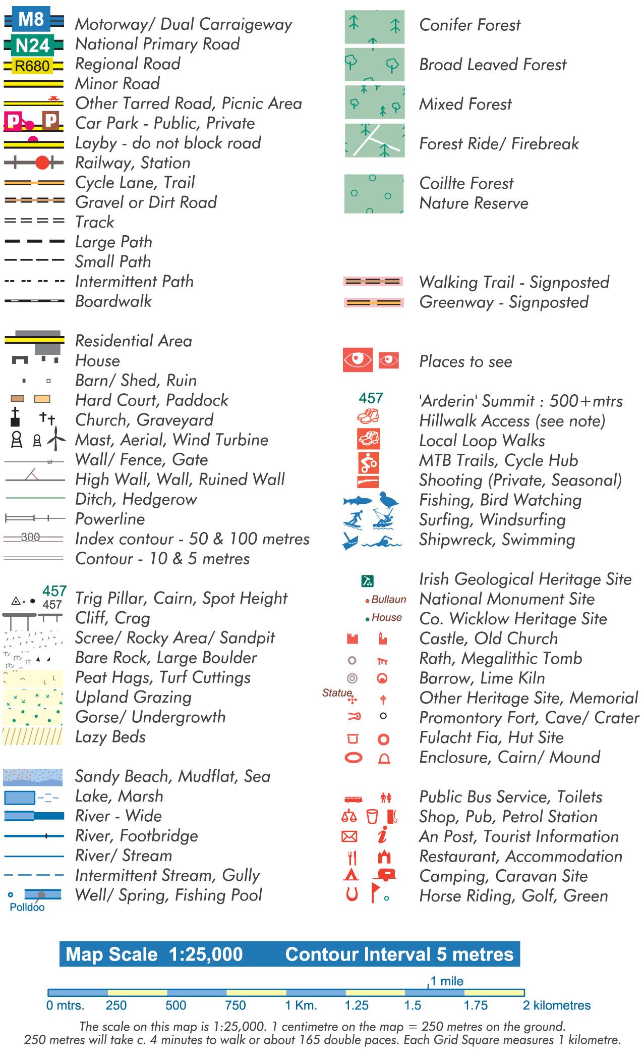
A: Our current topographic maps are mostly published in print form at 1:25,000 scale. Maps in our 25Series have a 5 metre contour interval. Older 1:25,000 maps have a 10 metre contour interval. We have also published maps at 1:30,000 scale in the past for parts of Dublin & Wicklow. These have now been replaced with maps to our 25Series standard. Maps in our walking guidebooks vary from 1:50,000 to 1:40,000 scale. These are quite adequate for following the walking trails but are not as detailed as our more general topographic mapping.
Q: How do I report an omission or error on a map?
A: We prepare our maps as carefully as possible but some detail may be missing or symbolised incorrectly. If you spot new detail or errors, please let us know via the Contact Form on this website and we’ll gladly investigate.
Q: Why is there an overlap between the sheets?
A: The overlap is designed for the convenience of users – to reduce the likelihood of having to carry more than one sheet when in a particular area.
Q: Care Instructions. Are EastWest Mapping maps waterproof?
A: Our maps are printed with four paper solutions: (1) Enduro paper is used on our Wild Nephin, Blackstairs and Achill maps. It’s a paper/plastic laminate 100 gsm weight, manufactured in Germany specifically for outdoor applications. Best described as two thin layers of paper sandwiching a sheet of plastic. It is water resistant and practically impossible to tear using normal pressure. Take care though not to start a cut with a scissors or sharp edge. If this paper gets wet or damp, avoid rubbing or abrasion – otherwise the thin layer of paper can rub off at creases etc. Protect it with a map case or plastic bag to avoid abrasion. If the map gets damp during use, on return open the map fully out and leave to dry in a well ventilated spot e.g. over back of a chair etc. It will dry, return to normal and can be refolded for use again. (2) All of our recent maps since 2018 are printed on Progeo map paper 90gsm, as used for map & charts. This is a good quality paper but it is not waterproof. For use outdoors, we recommend that you fold the map carefully before going out to the area you’ll be using, avoid stressing any folds and avoid using the same folding creases repeatedly. Insert the folded map into a conventional map case or two clear plastic freezer bags – into one bag, fold over open end and insert this end into second bag. (3) We offer the same Progeo maps in fully laminated or encapsulated versions if you require a durable and weatherproof solution for outdoor use. These are a little bulkier but will last many years. (4) Polyart paper is used on our Cooley and Dingle Way map publications. Polyart is a tough but light plastic material which is fully waterproof. You might choose to use a map case or freezer bag with it to add a bit of bulk. If you wish to laminate our Enduro paper maps, customers have reported to me that they’ve used (1) Milltech Digital Ltd., 021 4308925 [email protected] and (2) Map Shop Lamination, 083 1470099 [email protected]
Q: Map legend / Key to Symbols